
How to Read the Mount Longonot Trail, Gate, Crater Rim and Day Trip Route
A Mount Longonot map helps visitors understand the three most important parts of the hike: the park gate and trailhead, the main ascent toward the crater rim, and the crater rim trail that loops around the volcanic crater. The attached MtLongonot.org visitor map shows Mount Longonot as a crater-shaped hiking route, with the park gate/trailhead on the lower side of the map, the crater rim trail forming a loop around the volcano, and viewpoint or summit areas marked along the rim.
Below is the map prepared by MtLongonot.org useful for hikers:
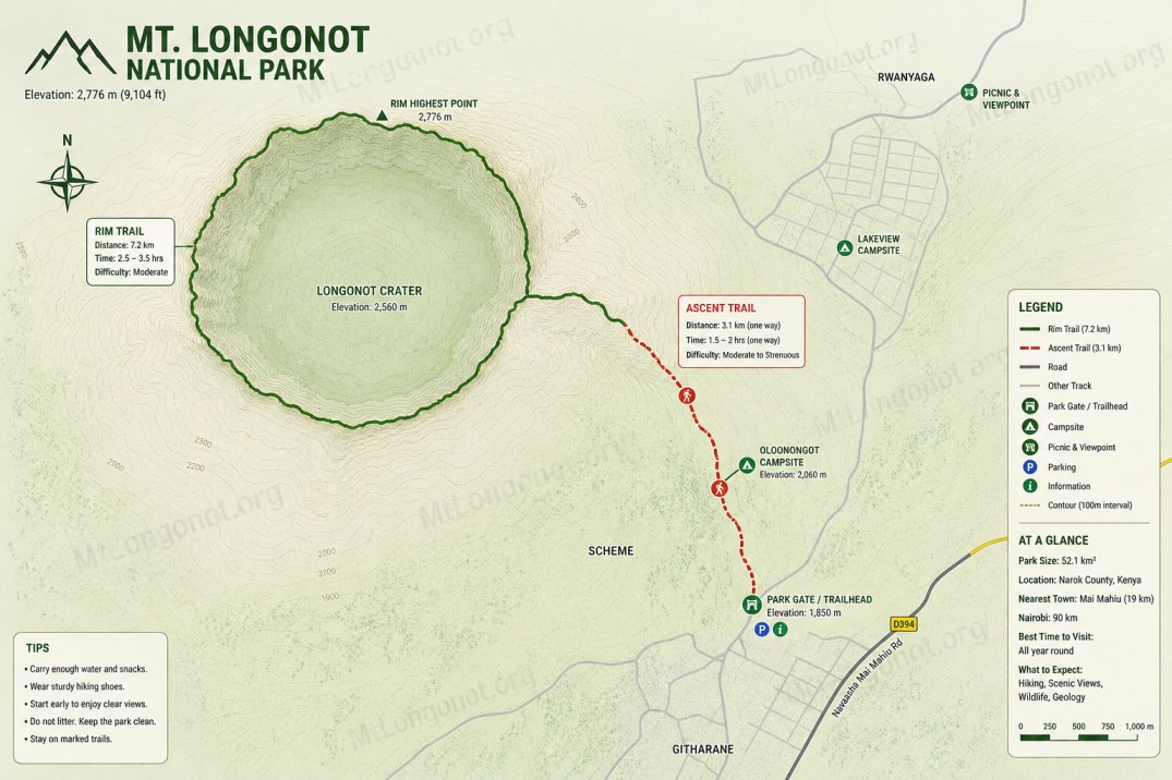
For visitors planning a day trip from Nairobi or Naivasha, the map should be used as an orientation guide, not as a replacement for live navigation, KWS gate instructions, weather judgment, or trail awareness on the ground.
Mount Longonot map at a glance
| Map feature | What it shows | Why it matters |
|---|---|---|
| Mount Longonot National Park | The protected area around the volcano | Confirms the hike is inside a national park |
| Park Gate / Trailhead | Starting point for the hike | Where visitors enter, park, pay, prepare, and begin walking |
| Main Ascent Trail | Route from the lower slopes toward the crater rim | The steepest and most important first section of the hike |
| Crater Rim Trail | Circular trail around the crater edge | Used by hikers doing the full rim circuit |
| Mt. Longonot Crater | The central volcanic crater | Main landscape feature of the mountain |
| Summit / high-point area | Marked on the crater rim | Main viewpoint and photo area for many hikers |
| Picnic & Viewpoint | Rest and viewpoint area | Useful for breaks, photos, and orientation |
| Scale bar | Shows approximate map distance | Helps visitors understand that the rim circuit is a real hike, not a short viewpoint walk |
| North arrow | Shows map orientation | Useful for reading direction and layout |
What does the Mount Longonot map show?
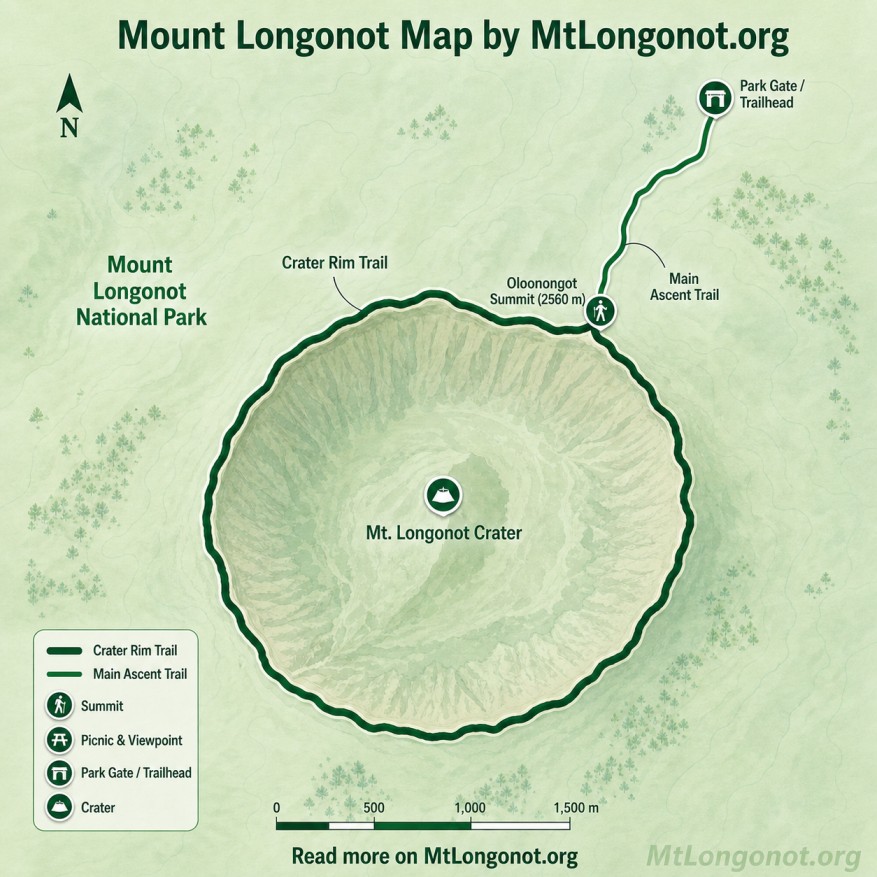
The Mount Longonot map shows the park gate and trailhead, the main ascent route, the crater rim trail, the central volcanic crater, summit or viewpoint points, and picnic areas. It helps visitors understand where the hike starts, how the trail reaches the rim, and how the full crater circuit loops around the volcano.
Where does the Mount Longonot hike start?
The Mount Longonot hike starts at the Mount Longonot National Park gate and trailhead, shown on the lower side of the map. This is where visitors arrive by car, taxi, tour vehicle, or boda boda, complete entry formalities, prepare water and gear, and begin the hike.
The trailhead is important because Mount Longonot is not a drive-up viewpoint. Visitors must walk from the gate area toward the crater rim. The first part of the hike is the ascent, and it is the section where many visitors first realize that Mount Longonot is a real physical hike rather than a casual stroll.
Where is the Mount Longonot crater on the map?
The Mt. Longonot Crater is shown in the centre of the map, inside the circular crater rim trail. The crater is the defining feature of Mount Longonot: the trail climbs up to the rim, and the full hiking circuit follows the edge around the crater rather than descending into the central crater area.
For most visitors, the crater is experienced from above. The main reward is standing on the rim and looking into the crater forest while also seeing the wider Great Rift Valley landscape beyond the mountain.
What is the crater rim trail?
The crater rim trail is the circular hiking route shown around the edge of the Mount Longonot crater. On the map, it appears as the thick dark-green loop around the volcano. This is the route used by hikers who want to complete the full crater circuit after reaching the rim.
Crater rim trail meaning
| Trail section | What it means for visitors |
|---|---|
| Rim entry point | Where hikers first reach the crater edge |
| Rim viewpoint | Where many visitors stop, rest, and take photos |
| Full rim circuit | The longer loop around the crater edge |
| Steeper rim sections | Repeated climbs and descents around the crater |
| Return to descent route | Where hikers reconnect with the trail back to the gate |
The full crater rim trail is more demanding than simply reaching the rim. It adds distance, sun exposure, loose volcanic soil, and repeated uphill and downhill sections.
Is the full Mount Longonot rim circuit shown on the map?
Yes. The attached map shows the full crater rim circuit as the loop around the crater. This is the route hikers follow if they want to walk around the entire crater rim before descending back to the park gate.
The full circuit should be treated as an optional extension, not an automatic requirement. Visitors who are fit, well-prepared, and hiking early can attempt it. Beginners, families with children, and visitors starting late may prefer to hike only to the crater rim viewpoint and return.
What is the difference between the main ascent trail and crater rim trail?
The main ascent trail is the route that takes you from the lower part of the mountain toward the crater rim. The crater rim trail is the loop around the crater after you reach the top.
| Trail feature | Main Ascent Trail | Crater Rim Trail |
|---|---|---|
| Purpose | Gets you from the gate area to the rim | Takes you around the crater edge |
| Difficulty | Steep climb | Longer, exposed, with repeated rises and descents |
| Best for | All hikers attempting Mount Longonot | Fit hikers with enough time and water |
| Main challenge | Climbing to the rim | Distance, heat, loose ground, fatigue |
| Can beginners do it? | Many can, with pacing | Only if fit and conditions are good |
| Should it be optional? | No, it is the main access route | Yes, especially for families and beginners |
Where is the Mount Longonot summit or high point on the map?
The map marks a summit or high-point area along the crater rim. This is where hikers get some of the most rewarding views of the crater, Lake Naivasha side of the Rift Valley, and surrounding volcanic landscapes.
For visitor-facing content, it is better to describe this as a summit or high-point area on the crater rim, because many hikers use the word summit loosely to mean the highest or most dramatic viewpoint reached during the rim walk.
Where is the picnic and viewpoint area?
The Picnic & Viewpoint label appears near the upper side of the map, connected to the trail system. This point is useful for visitors who want a rest stop, a photo point, or a place to orient themselves before continuing.
A picnic stop should be planned carefully. Mount Longonot is exposed, and hikers should avoid carrying heavy picnic supplies up the mountain unless the group is fit. For most day visitors, a better plan is to carry light snacks during the hike and have a proper lunch after descending.
Is the Mount Longonot map enough for hiking?
The Mount Longonot map is enough for general orientation, but visitors should not rely on it alone as a precise navigation tool. It is a visitor map, not a full topographic map or live GPS tracker. Use it to understand the layout of the hike, then follow the actual trail, signs, ranger advice, weather conditions, and your group’s energy level.
Use the map for
- understanding where the hike starts
- identifying the crater rim loop
- deciding whether to attempt the full circuit
- explaining the route to a group
- planning where to rest
- visualizing the difference between rim-only and full-rim hikes
Do not use the map for
- exact GPS navigation
- measuring exact hiking time
- replacing park staff guidance
- ignoring weather changes
- hiking off-trail
- estimating personal fitness too confidently
How should first-time visitors use the Mount Longonot map?
First-time visitors should use the Mount Longonot map to understand the hike in three stages: gate to rim, rim viewpoint, and optional crater circuit.
| Stage | Map meaning | Visitor decision |
|---|---|---|
| Stage 1 | Park gate/trailhead to crater rim | Start early and pace yourself |
| Stage 2 | First rim viewpoint | Rest, take photos, assess energy |
| Stage 3 | Crater rim loop | Continue only if fit, prepared, and on time |
| Stage 4 | Return descent | Save energy and descend carefully |
| Stage 5 | Gate return | Rejoin your driver or transport |
The best decision point is the crater rim. Once you reach the rim, decide whether to continue around the crater or return to the gate. That choice should depend on time, water, weather, heat, and fitness.
If interested in visiting, check out our Mount Longonot Day Tour from Nairobi page.